| |
| I went back to NZ to visit
family and friends, and spend a bit of time riding aimlessly about the
place. I haven't done that for a while so I thought it'd be a good way
to catch up with the place. In
December 2004 I rode north from Christchurch to Nelson via the
West Coast, then in January 2005 I
rode south and through the Otago Rail Trail |
 Takaka Hill Takaka Hill | But of course, I started with an overnight ride in Nelson. Just
up the Takaka Hill for a night. Then off to Christchurch on the bus to
help a friend build a wall. |
 Takaka Hill
Sunrise Takaka Hill
Sunrise | Slept somewhere just off the road in a comfy
patch of bush. Woke in time for sunrise, then off down the hill while
it was still cool. |
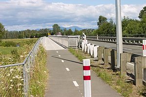
 Rakaia Bridge Rakaia Bridge |
Heading south from Christchurch after a few days helping Simon
build a wall in his garage. A hundred kilometres of flat, straight
road with not a lot to see or any way to skip it. So I just sat and
pedaled. Spent the night in a pine plantation near Hinds. A drink
bottle leaked inside a pannier so I did some clothes washing. Sitting
in a pine plantation is not very exciting, but my knees hurt a bit so
I'm stopped for the day. I played with the camera and bike computer...
98km at about 30kph, a little over 3 hours on the bike. |
 Geraldine Geraldine |
Rode to Geraldine (36km) then it started raining. Forecast is clearing
this evening, so I went to the library. New Zealand towns have
astonishingly good libraries compared to Australia. So that kept me
entertained for the rainy day. Met some interesting Germans (Tania and
Marcus) and biked out of town with them, but they had funny ideas
about camping so I left them to it. Camped in a(nother) pine
plantation 10km or so out of town. major achievement for the day was
buying a spoon (I lost my one at Simon's place). |
 Hills! Sheep! Hills! Sheep! | Getting noticeably away from the plains now. It was chilly
when I woke up so I went back to sleep until it warmed up. Undulating
roads into Fairlie, and the headwind started getting stronger. the
whole hilly headwind thing is not much fun, but it'd be less fun on an
upright. Forecast is for better wind tomorrow so plan a short day.
More knee pain. Bah! |
 Tekapo Tekapo | Woke
up, rode a few km to find somewhere in the sun to cook rice for
breakfast. Stopped at the Burkes Pass Cemetary, resting place for a
fair few mountaineers. The pass is short and reasonably steep, but
nothing like Porters Pass or Otira Gorge (in Arthur's pass), so I
breeze up that. At the bottom I'm taking photos and a bunch of merkins
come past, then they pass me again at the top as I'm taking more
photos. Quite amusing. Rest day in Tekapo and it's a tourist town, so
I'm in the backpackers. Rode up to Mt John Observatory for sunset,
then back down (now *that* is a hill :) |
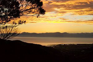
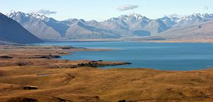
 Aoraki Aoraki |
Started out looking at the Southern Alps and Aoraki. Then cruised down
to the info centre by the hydro canal then rode the canal for a bit.
Directions mildly confusing, so reverted to the road. Went into
Twizel, shopped a bit then on to Omarama. Omarama is where the glider
kids go, but the useful thing for me was the weather forecast.
Southerly change = not pleasant. After a 10km stint into a headwind I
decided that I really needed dinner (a 125km day), so I did that then
decided that I was going to wimp out and stay in the farm labourers
cottage "backpackers". |
 Stealth Camp Stealth Camp |
No photos, just riding today. So here's how I camp. |
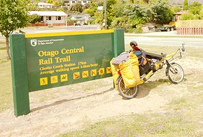 Otago Rail Trail Otago Rail Trail
| A big day for me. Saw the Clyde Dam, went shopping
in a supermarket (in a big town, even!), started riding to Otago Rail
Trail. |
 45� South 45� South |
Somewhere there's a photo of me at 15� South as well, during CANC2. This
is as close as I can find (near Capricorn Roadhouse, south of
Newman in WA). No journal notes, just photos. |
 Day 11 Day 11 | Last
day on the Otago Rail Trail, woke to early morning mist again and
headed for the highway rather than following the trail to its end. For
some reason the hilly highway seemed more like I remember Otago being
- perhaps because it's farmland rather than the river valley that the
rail trail ended on. Dry hilly country is more "real Otago". Then it
was out to the coast and on to Shag Point, home of the penguins. |
![]() Day 12 Day 12 | |
![]() Day 13 Day 13 | |
![]() Day 14 Day 14 | |
![]() Day 15 Day 15 | |
![]() Day 16 Day 16 | |
![]() Day 17 Day 17 | |
![]() Day 18 Day 18 | |
![]() Day 19 Day 19 | |
![]() Day 20 Day 20 | |
![]() Day 21 Day 21 | |
![]() Day 22 Day 22 | |
![]() Day 23 Day 23 | |
![]() Day 24 Day 24 | |
![]() Day 25 Day 25 | |
![]() Day 26 Day 26 | |
![]() Day 27 Day 27 | |
![]() Day 28 Day 28 | |
![]() Day 29 Day 29 | |
![]() Day 30 Day 30 | |
![]() Day 31 Day 31 | |
![]() Day 32 Day 32 | |
![]() Day 33 Day 33 | |
![]() Day 34 Day 34 | |
![]() Day 35 Day 35 | |
![]() Day 36 Day 36 | |
![]() Day 37 Day 37 | |
![]() Day 38 Day 38 | |
![]() Day 39 Day 39 | |
![]() Day 40 Day 40 | |
![]() Day 41 Day 41 | |
![]() Day 42 Day 42 | |
![]() Day 43 Day 43 | |
![]() Day 44 Day 44 | |
![]() Day 45 Day 45 | |
![]() Day 46 Day 46 | |
![]() Day 47 Day 47 | |
![]() Day 48 Day 48 | |
![]() Day 49 Day 49 | |
![]() Day 50 Day 50 | |
![]() Day 51 Day 51 | |
![]() Day 52 Day 52 | |
![]() Day 53 Day 53 | |
![]() Day 54 Day 54 | |
![]() Day 55 Day 55 | |
![]() Day 56 Day 56 | |
![]() Day 57 Day 57 | |
![]() Day 58 Day 58 | |